
Monday, November 27, 2006
Monday, November 20, 2006

11.20
Thoughts about a format for the final review...
Aside from a few minor glitches and disconnects, the process for the previous "live" review was successful.
Some suggestions:
having a professor in the room while we present (nostalgia factor?)
projects MEGAblogged ahead of time to familiarize the reviewers, due to a LARGE amount of foreign content
maybe the reviewers could also do some reading to familiarize (Corner articles?)
Friday, November 17, 2006
tsunami(resistant)housing
PROPOSAL
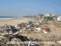
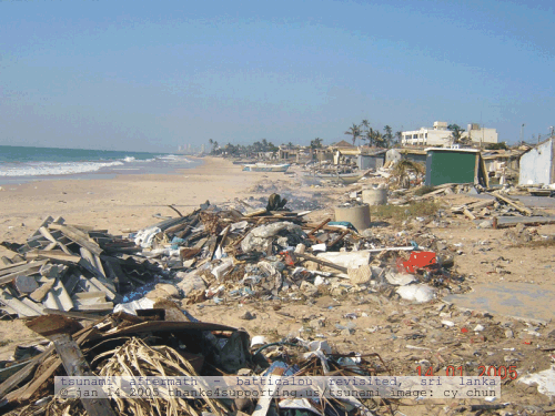
According to the International Viewpoint after the tsunami disaster in the Indian Ocean of December 2004, the government of many affected countries such as Sri Lanka are not allowing rebuilding on the coast.
Factors to consider:
PROGRAM LIST
MASSING MODELS
NOTE
I've noticed an interesting trend while analyzing post-tsunami photographs. It seems that load-bearing walls perpendicular to the coast line vertical elements of buildings and bridge supports most often survived the tsunami waves.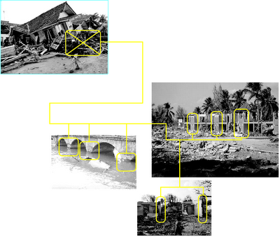
According to the International Viewpoint after the tsunami disaster in the Indian Ocean of December 2004, the government of many affected countries such as Sri Lanka are not allowing rebuilding on the coast.
“No new building structures will be permitted within 100 metres of the Western coast of the island. In the Eastern coast the distance where the construction will be permitted has been extended to 200 metres. New towns will have to be built one kilometre from the coast.”
This announcement obviously upset the Sri Lankan community. To offset this decision and offer a possible solution I am proposing tsunami(resistant)housing.
Factors to consider:
low cost
modularity
expandability
ease of construcion
permability
protected safe area
modularity
expandability
ease of construcion
permability
protected safe area
The goal of tsunami(resistant)housing is to allow the tsunami waves to pass through the house by creating an open plan oriented perpendicular to the coast line.
Another idea I'm considering in creating housing resistant to tsunami force waves is the use of vegetation. According to Adam White of Soils & The Environment "The roots of the vegetation also help to reduce the likelihood of soil erosion by flowing surface water. The roots stabilize the soil, acting as an anchor that holds the soil in place."
SITE
tsunami(resistant)housing can be implemented in any coastal area under threat of a tsunami, for this proposal I am suggesting Sri Lanka as a case study as the governemt is already taking action to prevent a repeat of the 2004 disaster where more than 31,000 people were killed.

 VIGNETTES
PROGRAM LIST
coastal housing
emergency alert/response center
social center
vegetation as foundation?
emergency alert/response center
social center
vegetation as foundation?
MASSING MODELS
NOTE
I've noticed an interesting trend while analyzing post-tsunami photographs. It seems that load-bearing walls perpendicular to the coast line vertical elements of buildings and bridge supports most often survived the tsunami waves.

MEGAtsunami
After the online review I redirected my project to map one of the effects of a terrestrial impact, mainly the MEGAtsunami. Upon conducting some research I found out that the only way a MEGAtsunami is generated is by displacing a very large amount of water all at once. Examples include a meteor impact or a LARGE scale landslide (incontrast to a tsunami which can be caused by earthquakes and plate subduction). Upon further investigation I discovered that the explosion of volcanos can lead to this type of large scale water displacement as the land from the volcano rapidly displaces water. I located 3 active volcanos that are potential threats for megatsunami's. One in the pacific (La Palma, Canary Islands), one in the atlantic (Kilaueau, Hawaii), and one in the Indian ocean (Piton de la Fournaise,La Réunion Island). I set the disturb tool to "circular wave" and set the paramiters so that the wave will show the travel time of the MEGAtsunami, between each peak of the waves on my map is 1hr of travel time from the MEGAtsunami's origin. I have separated my earth mesh into different sections so that each spread can be seen clearly. The section relates the height of the potential MEGAtsunami to the travel time.
 image showing the 3 potential megatsunami sites
 map showing travel time of the MEGAtsunami wave from t=0hrs to t=6hrs
 section relating distance traveled to height:
 east elevation diagram showing densities of the wave forms
 destruction mappings
Friday, November 03, 2006
Subscribe to:
Comments (Atom)
